Mount Gardner
 Mount Gardner is the tallest mountain
on Bowen Island, a 20 minute trip from Horseshoe Bay. We arrived in
time for the 9:30 sailing (see the current schedule at BC Ferries),
and walked on. About 15 minutes into the trip the ferry stopped to
let a sailboat race go past.
 We arrived at Killarney Lake
around 11 am and then started hiking up the mountain. The lake is a
park with trails around it an picnic tables on one end. We walked up
the road next to the lake and then started up the mountain.
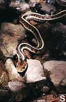
 At 1 in the afternoon we happened across a snake
sunning itself on the rocks in the tail.
 You could see the snake breathing (its little
sides expanding and contracting at a human-like rate) while Chris Lemay and
I circled firing off pics. Both these shots were done with my 24-70
IX lens (70 and 38mm respectivly) but I wish I had my 105mm. (Of course
my pants would be covered in mud if I did have it.) Once the snake
did wake up it scurried into a tree root system.
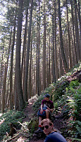
 On the trip up we passed though
rain forest, pine forest, and then some alpine. The mountain isn't
high enough to have true meadows so the only true vistas are when you get
to the top where BC Hydro has cut down the trees.
 Along the way we did get to glimpse the city
(through a lot of haze). It's always funny to see the city you started
in and know you have to walk all the way home (or at least to the terminal.)


This is the view from Gibsons to Squamish to Vancouver. There are
two helipads, and a whole heck of a lot of antennas, generators and repeaters
all surrounded by several layers of fences and barbed wire. We arrived
at 3:50ish so we didn't have much time before we had to head down.
John Harvey Photo > John Harvey Photo - Hiking > Mount Gardner on Bowen Island
John Harvey Photo > Mount Gardner on Bowen Island
John Harvey Photo > Photo Map of Vancouver > Mount Gardner on Bowen Island
Last Modified Tuesday, December 10th, 2002 at 21:31:30 Edit
Copyright and Contact Information.
 Mount Gardner is the tallest mountain
on Bowen Island, a 20 minute trip from Horseshoe Bay. We arrived in
time for the 9:30 sailing (see the current schedule at BC Ferries),
and walked on. About 15 minutes into the trip the ferry stopped to
let a sailboat race go past.


